

Beyond the celebrated pilgrimage town and summit cable cars, this department reveals a quieter rhythm of market towns, working valleys and carefully protected mountain lakes. Plan the journey around altitude, not just mileage: a short line on a map may involve a high pass, a narrow lane or an unexpectedly long stop for the view.
Plan your visit at a glance
| Destination | Hautes-Pyrénées, Hautes-Pyrénées, Occitanie |
|---|---|
| Best approach | Plan one principal outing and an optional local stop |
| When to go | Late spring to early autumn suits most low and mid-altitude walks; snow and ice can persist on high trails after nearby towns feel warm. |
| Ideal visit | Half-day to multi-day depending on the itinerary |
| Before leaving | Never assume a mountain road is open in winter or that a high-altitude lake permits swimming. |
On this page
- Read the valleys before choosing a route
- Start with towns, not summits
- A measured sequence for seven days
- What protected areas change
- Where the mountain day actually begins
- A slower alternative for non-drivers
- Make the trip responsible and distinctive
- Practical planning
- Frequently asked questions
Read the valleys before choosing a route
The landscape opens in several distinct directions. The Gave de Pau valley leads toward Argelès-Gazost, Luz and the glacial cirques; Campan and Gripp connect Bagnères-de-Bigorre to the Tourmalet; Aure and Louron lead to villages, high lakes and the Spanish frontier. Choosing two bases rather than changing accommodation each night removes unnecessary driving. An itinerary that looks compact on a national map may be slow on a mountain road, especially when cyclists, livestock or seasonal traffic share the lane.

Start with towns, not summits
Spend your first day in a town such as Tarbes or Bagnères-de-Bigorre. A market, a café and a walk through historic streets create useful context for the mountains that follow. In Argelès-Gazost, the thermal-town atmosphere and small centre make a pleasant transition to steeper valleys. Markets are part of local life, not guaranteed tourist performances; arrive early, buy from a small producer when possible and check the day before planning the rest of the route.
A measured sequence for seven days
A sensible progression might begin with Tarbes and Bagnères, turn toward Payolle and the Tourmalet when the road is open, spend two nights around Luz for short village walks and the Gavarnie side valleys, return through Argelès-Gazost, and finish in Louron or Aure. This is a framework, not a race. If the cloud base drops, exchange a mountain excursion for a museum or spa; if the forecast is stable, leave room for a longer lake walk rather than a second distant sight.
What protected areas change
The national park and the Néouvielle reserve are living habitats, not extensions of a resort. Dogs are excluded from the protected reserve; swimming and other water activities are prohibited in its lakes. Marked trails, sensitive shores and species-rich wetlands call for a slower approach than a typical picnic stop. Rules vary between the core park, reserves and ordinary valley land. Verify the precise boundary and restrictions before deciding where to walk, picnic or travel with a dog.
Where the mountain day actually begins
Every high-altitude outing needs an early check of weather, access roads and daylight. A paved approach does not imply that the last walk is smooth or suitable for sandals. Bring a warm layer even in midsummer, refill water before leaving a village, and plan a turn-around time rather than aiming for a distant summit at any cost. Families should distinguish lakeside promenades in a valley from rocky paths in high terrain. The latter can become slippery after short showers.
A slower alternative for non-drivers
Train journeys can bring you to towns such as Tarbes and Lourdes, but remote mountain attractions rarely sit beside a convenient station. Book local transfers or a planned day excursion where available, and check seasonal bus information instead of assuming a daily connection. A car-free visit is easier if you stay longer in one base and concentrate on its reachable walks, markets and indoor attractions, rather than trying to reproduce a driving itinerary with several transfers in one day.
Make the trip responsible and distinctive
Taste local cheeses and mountain produce in villages, and pay attention to the difference between a working pasture and a recreational lawn. Give grazing herds space and do not approach guardian dogs. In the evenings, choose a walk near your accommodation rather than another long drive. The best memories may be a quiet square after the day visitors have gone, changing light above an old bridge, or a conversation in a family-run restaurant rather than a new attraction crossed off a list.
How to arrive and get oriented
Before travelling to Hautes-Pyrénées, decide whether this outing is mainly an independent destination or one stop within a longer Pyrenees itinerary. Pick bases by valley, reserve one weather-flexible day and check high passes before departure. Journey times increase sharply during summer roadworks or sporting events. The most reliable approach is to check the local operator or tourist office shortly before departure, particularly when a mountain pass, timed ticket or seasonal service is involved.
A realistic half-day or full-day plan
Try this sequence as a flexible starting point: Tarbes → Bagnères-de-Bigorre → Payolle or Tourmalet → Luz → Argelès-Gazost → Loudenvielle, adjusting for actual pass openings. Treat it as an order of activities rather than a promise about travel time; the day will feel more satisfying if a delayed start does not force you to skip a meal or rush a viewpoint.
The right season and the right hour
Late spring to early autumn suits most low and mid-altitude walks; snow and ice can persist on high trails after nearby towns feel warm. Many popular Pyrenees locations have a very different atmosphere on an early weekday and a peak-holiday afternoon. Aim for good light and manageable temperatures rather than automatically following the busiest arrival time.
Walking, terrain and conservation
The department includes forest, meadows, high granite lakes and limestone cirques; each environment offers different conditions and conservation priorities. Think carefully about the actual surface underfoot: a lakeside path, an old town lane and an alpine trail impose different demands. Suitable footwear and a layered clothing system matter even if the outing is described as short.

Visiting with children or limited mobility
Combine easy valley promenades with a single carefully selected wildlife or heritage visit instead of forcing children through several long journeys. Explain the main character of the outing to younger visitors in advance, especially if it involves a reservation, long walk, cold interior or an enforced conservation rule.
Where to stay and how long
Two or three nights around Bagnères or Argelès-Gazost, and another two or three in a second valley, are usually more restful than daily relocations. For most travellers, the accommodation's position relative to an evening meal and the next morning's route matters more than finding a nominally central point on a regional map.
What to pack and what to verify
The most useful kit is often simple: water, suitable shoes, weather layers, sun protection, a charged phone and offline directions. Around Hautes-Pyrénées, assess whether a booking confirmation, change of shoes or warmer jacket belongs on the list too. Never assume a mountain road is open in winter or that a high-altitude lake permits swimming.
How this guide connects to the wider region
A trip to Hautes-Pyrénées becomes more interesting when you understand it as part of the wider Hautes-Pyrénées landscape, rather than an isolated attraction. Look for connections in architecture, food, local language and the way people move between villages and mountains. Not every neighbouring place needs to be visited immediately; some make a natural reason to return.
More ways to experience Hautes-Pyrénées
A seven-day outline that leaves room for change
Days one and two can focus on Tarbes and Bagnères before a quiet outing toward Payolle. On the third day, cross toward Luz only if the Tourmalet is legally open and the forecast is appropriate; otherwise travel by a lower route. Reserve day four for a single glacial cirque rather than three. Day five belongs to the Argelès-Gazost area, day six to the Aure or Louron valley, and day seven to a short local activity before departing. This sequencing reduces backtracking, although actual drives still need confirmation on a current map.
When a landmark is already in another guide
If you already have our published guides to Lourdes, Gavarnie or Pic du Midi, use them for the specifics of those attractions. This regional itinerary serves a different question: how can they fit together without consuming all your holiday in transit? The answer depends on separating busy sightseeing days from restorative ones. For example, pair a church or market visit with a gentle afternoon rather than with a full high-altitude hike. A night near a valley you want to explore is often worth more than a marginal saving on hotel costs.
An alternative when the high mountains are in cloud
Mountain forecasts are frequently more restrictive than forecasts for towns. If the upper valleys are foggy, use the day for village food, craft shops, thermal heritage or a short lower-level walk. Do not drive toward a reserve hoping that conditions must improve after the next bend. Some attractions require bookings, but leave at least one genuinely flexible day in the plan. This is also a good opportunity to learn about pastoral activity and the way local towns serve both visitors and year-round residents.
Travel slowly enough to notice differences
The language of travel advertising tends to group the Pyrenees into a single scenery category. Yet a limestone cirque, a granite lake basin, a wooded valley and an old market town feel surprisingly different. Look for changes in stone, vegetation, architecture and food rather than checking off the highest number of famous names. That approach makes a seven-day itinerary interesting even for travellers who do not hike far. It also helps decide which part of the department deserves a longer return visit.
Related guides on MyFranceExperience
If you are planning a longer journey, continue with our Tarbes travel guide, Bagnères-de-Bigorre, Lourdes travel guide and French Pyrenees year-round guide. These guides help you build an itinerary with distinct experiences rather than treating every valley as interchangeable.
Where to stay and what to verify before the road trip
For overnight options, compare accommodation around Hautes-Pyrénées on Booking.com. Compare cancellation terms, actual location and the journey to your first planned attraction; the nearest place on the map is not always the most convenient.
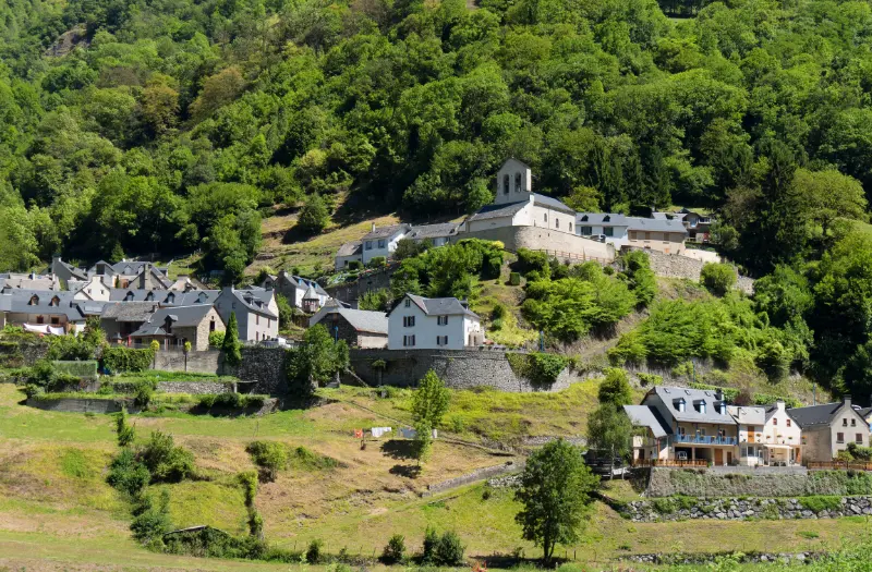
For this seven-day Hautes-Pyrénées journey, check the departmental tourism information for access to the specific valleys and mountain sites you plan to visit. A walk near Lourdes involves different conditions from a high-altitude lake or a road toward Gavarnie. Confirm restrictions, weather and seasonal access for each day before fixing your overnight route.
Frequently asked questions
Is Hautes-Pyrénées worth including in a first Pyrenees holiday?
Yes, if the subject matches your interests. Hautes-Pyrénées can bring a different perspective to a wider itinerary, but it is better to spend adequate time here than to attach a rushed stop to an already full day.
Can I visit without a car?
Parts of the Hautes-Pyrénées can be explored from towns served by rail or local buses, but this itinerary links valleys and trailheads that are not always easy to combine without a car. If you plan to travel by public transport, choose fewer bases and verify the last return connection for every excursion. A taxi or organised transfer may be worth considering for one remote day, rather than assuming a regular bus will reach the trailhead.
What season should I choose?
Late spring to early autumn suits most low and mid-altitude walks; snow and ice can persist on high trails after nearby towns feel warm. Always verify the current local weather and operational calendar.
Is this suitable for children?
Combine easy valley promenades with a single carefully selected wildlife or heritage visit instead of forcing children through several long journeys. Review the exact route or operator requirements before committing.
What is the most important thing to check before setting off?
Never assume a mountain road is open in winter or that a high-altitude lake permits swimming. Consult current official information rather than using an old timetable or a general map.
Last updated: 21 October 2026